By Katechis Alexandros
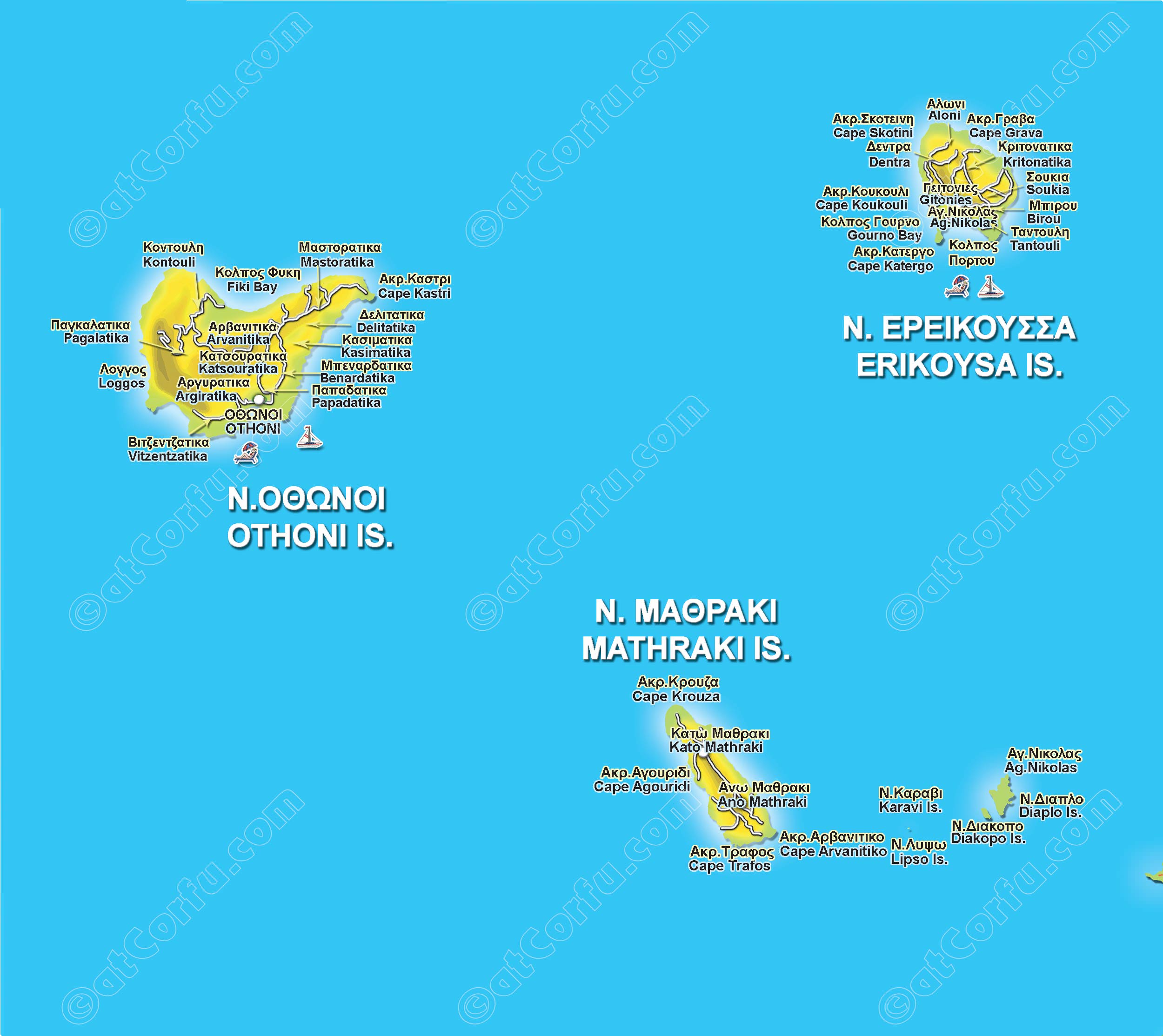
Diapontia Islands are located 10 km from Corfu island, 43 km from the cape of Otranto and 48 km from Santa Maria di Leuca in Italy, consists of three larger islands, Othoni, Ereikoussa and Mathraki (with 1217 inhabitants according to the 2011 census) and from 9 uninhabited rocky islets. Together with central Corfu, they form the newly established municipality of Central Corfu and the Diapontian Islands.
(The island of Sazan, west of Albania, is considered part of the Diapontian Islands.)
Brief historical background
The treaty signed on March 29, 1864 between the three Great Powers (England, France, Russia) and the Kingdom of Greece, the Ionian Islands (and the Diapontia Islands) finally came under Greek rule on May 21. On October 5, 1864, the Ionian Parliament convened for a union with Greece under King George A. From 1869 to 1912, the Othoni , Mathraki and Ereikoussa formed the “Municipality of the Diapontian Islands” with Othoni as their capital. In 1913, Greece evacuated Sazan.
The Diapontia have a rich naval and shipping history. Many men were involved in shipping. Indicatively, in 1875 the 67% of the Othonian professionals were sailors and another 13% Masters. Until the middle of the 20th century, the Othonian merchant fleet traveled to many ports in the Mediterranean and the Black Sea, while many inhabitants had sailing boats. They served the needs of the islands, transported agricultural and industrial products to and from Epirus, the Albanian coasts, Austria-Hungary, Italy and Malta, while transporting local and Corfiot oil. Many Diapontian sailors were lost at sea. A monument in the port of Ammos recalls it, dedicated to the sailors who perished in a shipwreck in 1991. Today, overseas officers and other workers in the Merchant Shipping sector are few.
Othoni
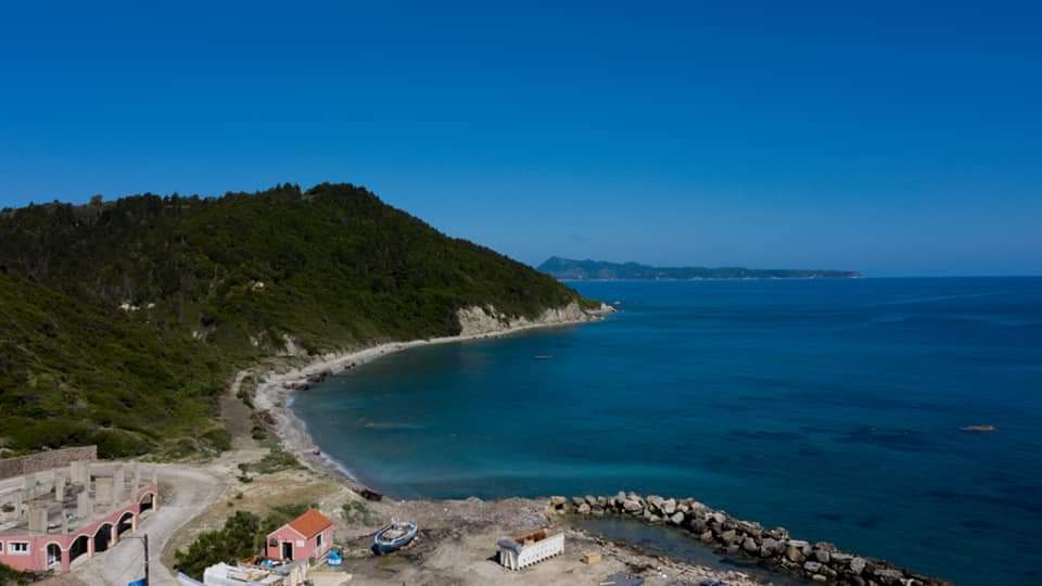
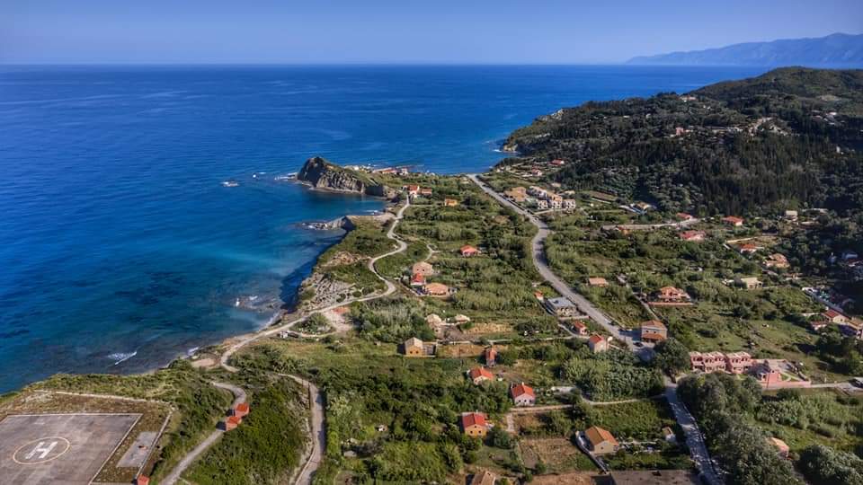
With an area of 11 sq.km, Othoni is the largest in the Diapontia Islands archipelago and is the westernmost point of Greece with 392 inhabitants according to the 2011 census. This is a tourist place, suitable for sailing and quiet holidays. The ferries leave the visitor in “Ammos,” a bay with a nice beach and a few shops.
In Othoni there are more than 15 settlements with about 10-20 houses each with the older “Chorio” which is the westernmost settlement of Greece. At the northeastern end, at Cape Kastri, on an altitude of 100m, near the ruins of the Venetian fortress there is the lighthouse of the island. Built in 1872, it has a height of 13m. On the island there are a number of paths created and used by the inhabitants of the island and today they are open again thanks to the services of the municipal authority and many private initiatives. They give the opportunity to locals and visitors to go through them and reach each neighbourhood on foot. “Imerovigli” which is the highest peak of Diapontia with a height over 390 meters is easily accessible in a short time thanks to the traditional path (~ 1000 meters long, opened by private initiative of locals) and leads to the top of the island.

Most of the coasts are steep and rocky while in the west there is the beautiful beach “Aspri Ammos” with the cave of “Calypso” and in the north the bay “Fyki”. “Avlakia” is the fishing shelter of Othoni, in which is the unfinished new port of the island, next to the seaside settlement “Ammos”.
The Othonians, like the other Diapontian Islands, are served by military doctors while there is a port and police station on the island. They have a helipad which is not used and has been closed for years. The permanent demands of the permanent residents are the completion of the port of the island, the modernization of the electricity supply, the interconnection of the island with a new ships, as the island is cut off for several days every year, the placement of PPC aerial in the winter months, the re-creation of the “Municipality of the Diapontian Islands” which was abolished at the beginning of the 20th century but also the creation of a military outpost on the island to feel more secure.
Ereikoussa
At a distance of 6 miles north of Corfu, is Ereikoussa, the northernmost of the Ionian Islands with 496 inhabitants according to the 2011 census.
It owes its name to the Reiki bush, of which the island is full and which bloom in October.

One of the most beautiful places on the island is “Pera Katergo” where the view becomes wilder. Pera Katergo, is the only part of the island covered with stone, a valuable raw material for the needs of the island of the last century.
As for the beaches, this one in the settlement “Porto” is probably the most impressive. There are 6 settlements with about 20 houses each. The traveler should not forget to visit the coast of Braggini, to enjoy its wonderful waters and to admire the vegetation that covers the landscape as a whole.
Its only port, Porto, reconstructed in 2018 with a wonderful beach and remarkable facilities, is connected to the port of Corfu.
The request of the permanent residents is the modernization of the electricity supply and the transport with a new and faster ship (but also the installation of A.T.M. something that is missing from all three islands). Despite the announcements for incentives for new families to settle in Diapontia, to this day this remains only a promise.
Mathraki
With an area of 3 sq.km, Mathraki is the smallest of Diapontia Islands (329 inhabitants according to the 2011 census). It is located west of Corfu and is 4.5 nm. from Agios Stefanos Avlioton. Its port is “Plakes,” which is connected to Corfu, from the port of Agios Stefanos and from Sidari.
At both ends of the island are its two villages, Ano and Kato Mathraki. It has two hotels and picturesque taverns. Its most enchanting beach is “Portelo” which is a vast sandy beach three kilometers long edging shallow waters.

In Mathraki there are many settlements that are connected by picturesque paths. Notable places are “Fyki bay”, “Trachia islet”, the old port with the picturesque settlement and “Apides” with the small port for fishing boats.
On Mathraki, the desalination plant is not yet fully operational due to bureaucratic reasons. The port is not functional and often the inhabitants of the island are cut off. Many projects on the island have been financed by expatriates, something that applies to the other two Diapontia.
Despite the adversities, the few and old inhabitants of the Diapontian Islands, remain on their islands, enjoying the innumerable beauties of their place, striving for a better life, through many hardships and often running out of things that for some of us they seem self-evident (electricity, medical care, etc.) and having for years the same needs but also the same demands, such as better transportation coverage. The indifference of the state (which is weak or simply does not want to understand the importance of this place), as well as of many inhabitants, have brought these islands into decline and the risk of complete abandonment seems real.
However, there are many who do not accept to be deported from their homeland while many choose to return permanently from the USA and other parts of Greece to live, at least, the last years of their lives there. In the years of crisis the interest for permanent establishment and business activity in the islands of many Diapontians living in Corfu somas great while the investment interest of locals and foreigners is higher than other times.
The Diapontia Islands, which several times seem neglected by the central state, are an integral part of Greece and their inhabitants raise the Greek flag, in defiance of those who see them as a negligible quantity or even as their future booty…
Katechis Alexandros is the creator and curator of http://www.diapontia.gr/ and he is of Othonian origin.
